


Good Caring Canada brings you real-time camera views of traffic along the Gardiner Expressway, from Highway 427 to the Don Valley Parkway—a vital corridor for commuters crossing Toronto from west to east and back again.
⬇️ Scroll down to follow the Gardiner Expressway one segment at a time—from the western suburbs to the foot of the Don Valley.
For each segment, you will find a live traffic camera image—automatically refreshed every few minutes—alongside a description of what you are seeing. These include nearby entry and exit ramps, overpasses, merges, and key roadway features.
To help with trip planning, each segment includes an estimated travel time to Don Valley Parkway—both under normal conditions and during peak hours. These reference points provide a practical sense of how far along you are, and how much time remains based on current conditions.
Live camera feeds may occasionally be unavailable due to technical interruptions or scheduled maintenance. In such cases, readers are encouraged to refresh the page or return later for updated views.
Gardiner Segment-by-Segment View
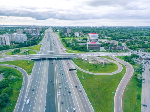
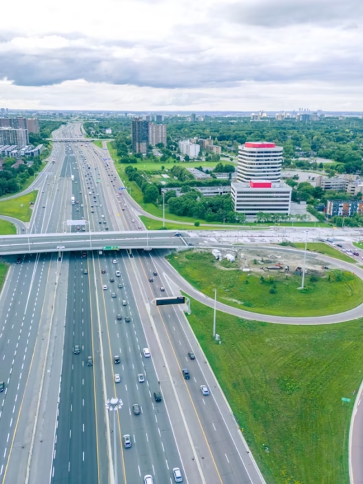
1. Near Highway 427

This segment marks the western starting point of the Gardiner Expressway, where eastbound lanes emerge from Highway 427 and multiple ramps converge from the north and west. The camera overlooks a wide swath of pavement, bordered by sound walls and commercial structures. Travel time to the Don Valley Parkway is approximately 18 minutes in light traffic and up to 40 minutes during peak periods.
2. Near Kipling Avenue
This view captures the expressway just past the Kipling Avenue overpass, where no ramps are present. The road is elevated and enclosed by concrete barriers with adjacent rail lines visible in the distance. From here, travel to the Don Valley Parkway takes about 17 minutes in clear conditions and up to 38 minutes when congestion builds.
3. Near Islington Avenue
Positioned east of the Islington Avenue interchange, this segment includes an eastbound on-ramp merging from the north. The camera often shows vehicles accelerating into the rightmost lane beneath surrounding office and mid-rise residential structures. Estimated travel time to the Don Valley Parkway ranges from 16 minutes under normal flow to 35 minutes in peak periods.
4. Near Royal York Road
East of Royal York Road, the Gardiner continues as an elevated structure. The camera overlooks a stretch of uninterrupted freeway flanked by trees and urban rooftops, with no ramps in view. A typical drive to the Don Valley Parkway takes 15.5 minutes in light traffic and up to 33 minutes when conditions are heavy.
5. Near Park Lawn Road
This segment includes the key interchange with Park Lawn Road, one of the last major exits before downtown. The camera captures merge zones and entry ramps from both the south and north sides. Travel to the Don Valley Parkway takes around 14 minutes in free-flowing traffic or as much as 32 minutes during peak times.
6. Near South Kingsway
Here, the Gardiner curves along the lakeshore and passes under South Kingsway. The elevated structure is bordered by rail lines and wooded slopes. There are no active ramps at this location. From this point, travel time to the Don Valley Parkway is about 13.5 minutes in light traffic or 30 minutes during heavy flow.
7. Near Parkside Drive
The camera shows the section approaching Parkside Drive, with Lake Ontario on one side and High Park on the other. Though there are no ramps, this area often experiences speed variations due to the subtle curve and scenery. Travel time to the Don Valley Parkway is typically 13 minutes in normal conditions and 28 minutes at peak.
8. Near Dufferin Street
The Dufferin Street overpass frames this segment, with the Gardiner running beneath. While there are no direct entry or exit ramps here, adjacent city streets feed local traffic toward on-ramps nearby. Expect a 12-minute trip to the Don Valley Parkway in light flow, and up to 27 minutes when delays increase.
9. Near Strachan Avenue
This camera overlooks the elevated portion near Strachan Avenue, where the road is suspended above Liberty Village and close to Exhibition Place. There are no direct ramps at this stretch, but nearby access points influence flow. Travel time to the Don Valley Parkway is about 11.5 minutes under normal traffic and 26 minutes when busy.
10. Near Bathurst Street
The Gardiner passes beneath Bathurst Street here, flanked by tall buildings and mid-rises. The view shows steady through traffic, with no ramp activity in this location. Travel to the Don Valley Parkway from here is typically 11 minutes in light traffic or up to 25 minutes during peak hours.
11. Near Spadina Avenue
Spadina Avenue crosses overhead, and this segment includes ramp activity nearby, with traffic potentially merging or exiting east of the view. The elevated structure provides a clear path toward downtown. The trip to the Don Valley Parkway averages 10.5 minutes in good conditions or 24 minutes during heavier flow.
12. Near Rees Street
This portion of the expressway is surrounded by dense downtown development. The camera captures views near Rees Street, with limited ramp movement but increased urban traffic density. Expect about 10 minutes to reach the Don Valley Parkway under normal flow and up to 23 minutes when traffic intensifies.
13. Near York Street
Approaching the core, this segment includes ramps connecting to downtown Toronto’s financial district. Lane changes and merging are common as drivers prepare for exits or continue east. Travel to the Don Valley Parkway takes approximately 9.5 minutes in light traffic or 22 minutes at peak.
14. Near Jarvis Street
This camera shows a complex section near Jarvis Street, with multiple ramp options, lane divisions, and signage directing vehicles toward the Don Valley Parkway or surface routes. In clear conditions, the trip to the Don Valley Parkway is around 8 minutes, or up to 20 minutes during heavy congestion.
15. Near Cherry Street
East of Jarvis Street, the Gardiner begins transitioning into lower-level alignments. This area includes visible merges from Lake Shore Boulevard and ramps leading toward the Port Lands. Travel time to the Don Valley Parkway is typically 6 minutes when traffic flows well, and 15 minutes when conditions tighten.
16. Near Don Valley Parkway
This final segment captures the eastbound split where vehicles exit onto the Don Valley Parkway or continue toward the Don River bridges. Overhead signs, barrier transitions, and ramp diverges dominate the view. This marks the beginning of the Don Valley Parkway, with northbound travel continuing toward York Mills Road.